- Australia ▾
- Topographic
▾
- Australia 50k Geoscience maps
- Australia 100k Geoscience maps
- Australia 250k Geoscience maps
- Australia 1.1m Geoscience maps
- New Zealand 50k maps
- New Zealand 250k maps
- New South Wales 25k maps
- New South Wales 50k maps
- New South Wales 100k maps
- Queensland 10k maps
- Queensland 25k maps
- Queensland 50k maps
- Queensland 100k maps
- Compasses
- Software
- GPS Systems
- Orienteering
- International ▾
- Wall Maps
▾
- World
- Australia & New Zealand
- Countries, Continents & Regions
- Historical
- Vintage National Geographic
- Australian Capital Territory
- New South Wales
- Northern Territory
- Queensland
- South Australia
- Tasmania
- Victoria
- Western Australia
- Celestial
- Children's
- Mining & Resources
- Wine Maps
- Healthcare
- Postcode Maps
- Electoral Maps
- Nautical ▾
- Flags
▾
- Australian Flag Sets & Banners
- Flag Bunting
- Handwavers
- Australian National Flags
- Aboriginal Flags
- Torres Strait Islander Flags
- International Flags
- Flagpoles & Accessories
- Australian Capital Territory Flags
- New South Wales Flags
- Northern Territory Flags
- Queensland Flags
- South Australia Flags
- Tasmania Flags
- Victoria Flags
- Western Australia Flags
- Gifts ▾
- Globes ▾
Dear valued customer. Please note that our checkout is not supported by old browsers. Please use a recent browser to access all checkout capabilities


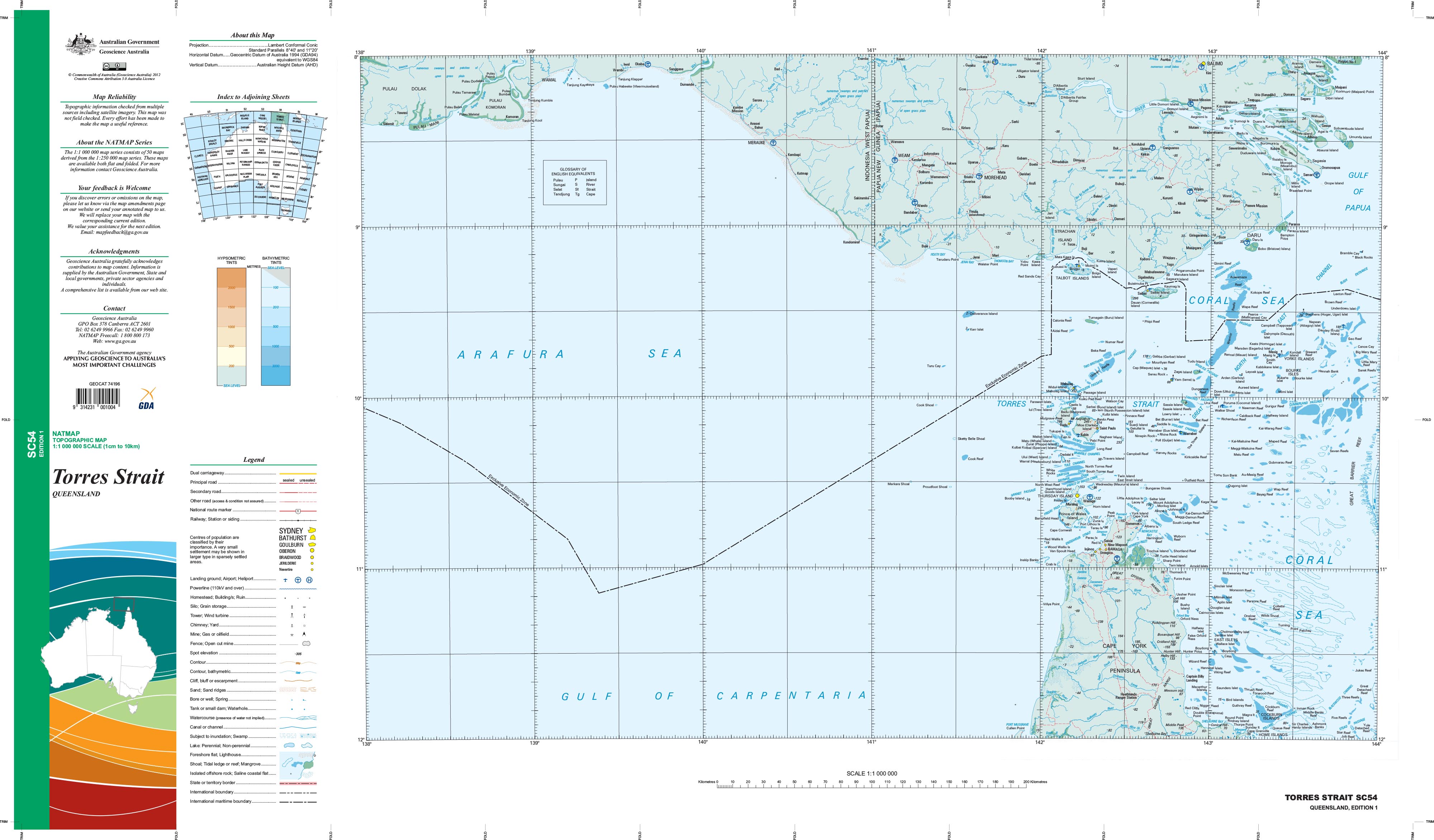
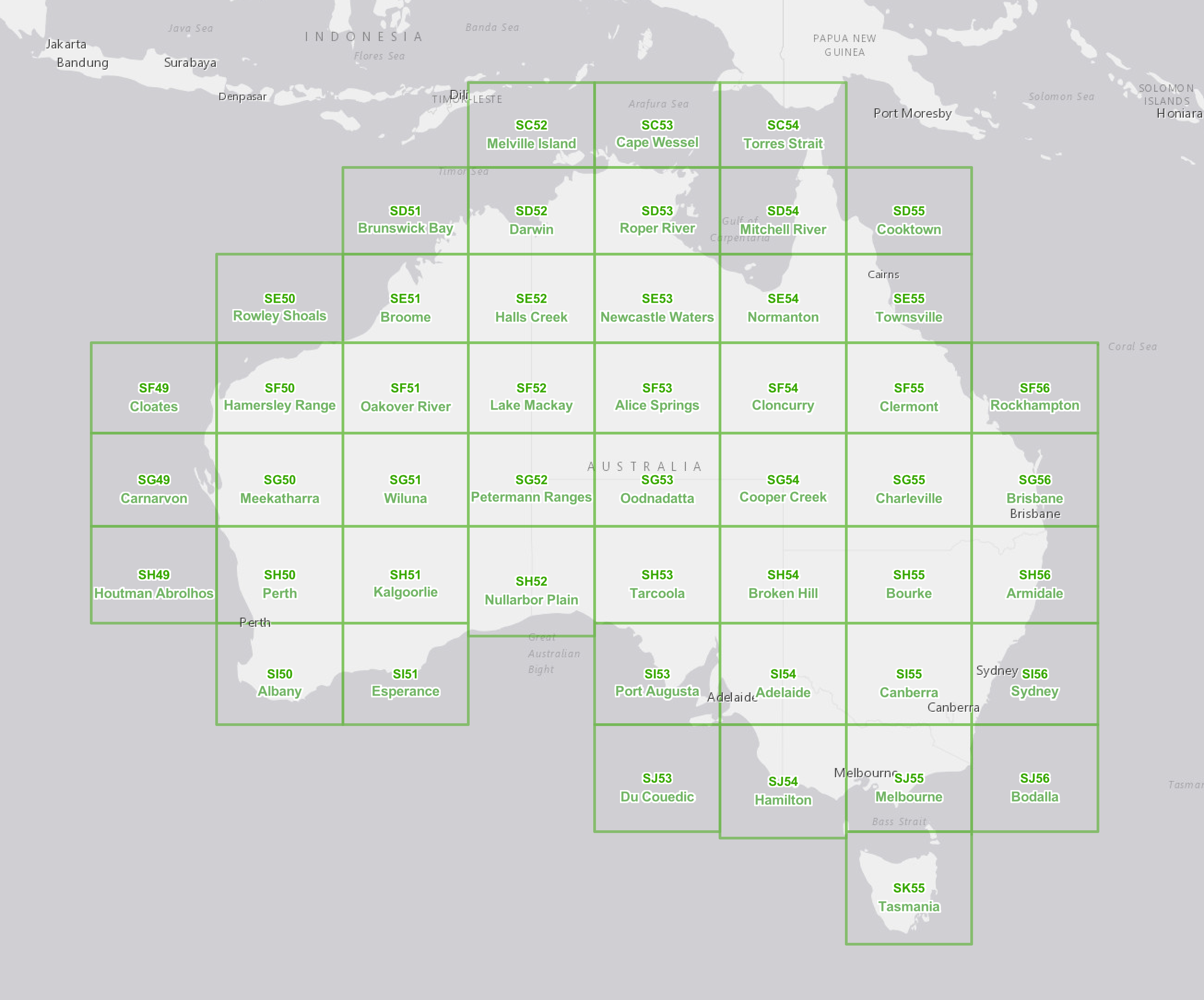
SC-54 Torres Strait 1:1 Million General Reference Topographic Map
$19.95
Afterpay is only available for orders between $50.00 and $1000.00 More info
This map is part of a series that comprises 50 maps that cover the whole of Australia at a scale of 1:1 000 000 (1cm on a map represents 10km on the ground). Each standard map covers an area of 6 degrees longitude by 4 degrees latitude or about 590 kilometres east to west and about 440 kilometres from north to south. These maps depict natural and constructed features, including transport infrastructure (roads, railway airports), hydrography, contours, hypsometric and bathymetric layers, localities and some administrative boundaries, making this a useful general reference map.
Topographic maps show contours, spot elevations, streams, roads, buildings, place names, vegetation and administrative boundaries. They are used by emergency services, environmental resource managers, engineers and others for planning, development and recreational activities.
If you would like to use this map in the field, then we can supply it on waterproof/tearproof DuPont™ Tyvek®. Tyvek® is made of pure polyethylene fibres (plastic) but has the properties of paper, which means it is foldable.
We can also laminate this map, which will allow you to draw on it in whiteboard marker or apply our map dots to locations of interest without permanently marking the map. The lamination also makes the map very durable and protects against tears and stains.
Coverage: The whole of Australia is covered with 49 maps (please refer to Status). National coverage was first completed in 1975.
Currency: IMW 1971 to 1983. General Reference Topographic 2008-2011
Coordinates: Geographical
Datum: AGD66 (GDA94 compliant at this scale); AHD
Projection: Lambert Conformal Conic
Status: The IMW are no longer maintained, and some maps may not be available. A new series based on the World Aeronautical Charts (WAC) series of maps was completed in early 2011 and is known as the 1:1 million General Reference Topographic Map Series.
Scale: 1:1,000,000
Size: 920 mm (w) x 540 mm (h)
Related Items


© 2024 Mapworld. Website designed by Genie Media
X