- Australia ▾
- Topographic
▾
- Australia AUSTopo 250k (2025)
- Australia 50k Geoscience maps
- Australia 100k Geoscience maps
- Australia 250k Geoscience maps
- Australia 1:1m Geoscience maps
- New Zealand 50k maps
- New Zealand 250k maps
- New South Wales 25k maps
- New South Wales 50k maps
- New South Wales 100k maps
- Queensland 10k maps
- Queensland 25k maps
- Queensland 50k maps
- Queensland 100k maps
- Compasses
- Software
- GPS Systems
- Orienteering
- International ▾
- Wall Maps
▾
- World
- Australia & New Zealand
- Countries, Continents & Regions
- Historical
- Vintage National Geographic
- Australian Capital Territory
- New South Wales
- Northern Territory
- Queensland
- South Australia
- Tasmania
- Victoria
- Western Australia
- Celestial
- Children's
- Mining & Resources
- Wine Maps
- Healthcare
- Postcode Maps
- Electoral Maps
- Nautical ▾
- Flags
▾
- Australian Flag Sets & Banners
- Flag Bunting
- Handwavers
- Australian National Flags
- Aboriginal Flags
- Torres Strait Islander Flags
- International Flags
- Flagpoles & Accessories
- Australian Capital Territory Flags
- New South Wales Flags
- Northern Territory Flags
- Queensland Flags
- South Australia Flags
- Tasmania Flags
- Victoria Flags
- Western Australia Flags
- Gifts ▾
- Globes ▾
Dear valued customer. Please note that our checkout is not supported by old browsers. Please use a recent browser to access all checkout capabilities


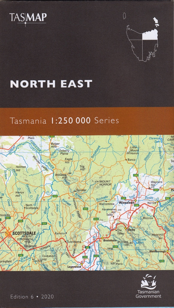
Tasmania North East Tasmap Map
$19.95
Afterpay is only available for orders between $50.00 and $1000.00 More info
🗺️ North East Tasmania Map – TASMAP 1:250,000 Regional Series
Explore the quiet beauty and winding backroads of Tasmania’s northeast
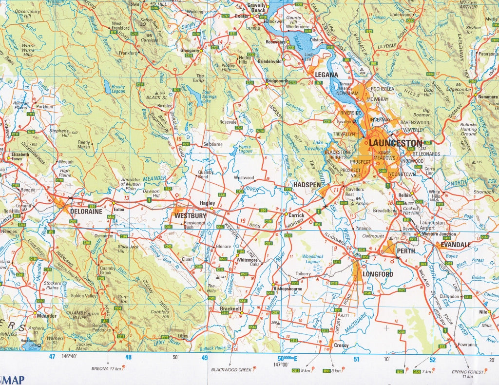
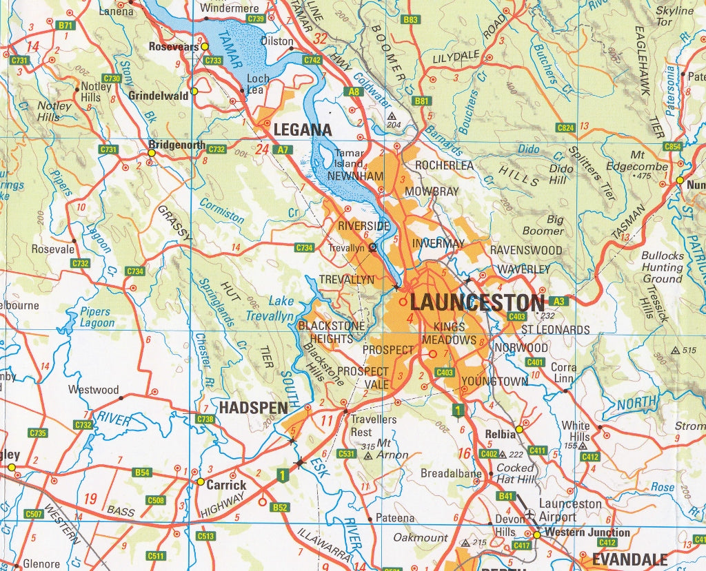
The North East Tasmania Map by TASMAP is part of a high-quality four-map series that together cover the entire island of Tasmania, including insets for Macquarie Island and King Island. This specific sheet focuses on the northeast corner of Tasmania — a region renowned for its rugged coastlines, temperate rainforests, rich farming country, and quiet, winding inland roads.
Covering approximately 37,000 square kilometres, this map is perfect for travellers, cyclists, regional planners, and locals looking to explore beyond Tasmania’s main tourist routes. With its precise detail and topographic representation, this is a must-have for those seeking a deeper understanding of the region’s landscape, roads, and communities.
📍 Regional Coverage Includes:
-
Launceston, George Town, and the Tamar Valley
-
Scottsdale, Branxholm, and Derby – gateway to Blue Derby MTB trails
-
St Helens and the stunning Bay of Fires coastline
-
Ben Lomond National Park and alpine highlands
-
Eddystone Point, Bridport, Lilydale, and inland farming communities
🧭 Key Map Features
✅ Scale: 1:250,000
A balanced scale ideal for both regional overview and road-by-road navigation
✅ Road Network Classification
-
Roads are symbolised by surface type (sealed, unsealed) and importance in the state network
-
Distance markers included between towns and major intersections for easy trip planning
✅ Topographic Detail
-
Contours at 100-metre intervals to represent elevation and terrain
-
Enhanced with hypsometric tinting and hillshading to visually depict the shape of the land
-
Excellent for understanding terrain – perfect for cyclists, planners, and environmental mapping
✅ Inset Maps
Each map in the series includes smaller insets of Macquarie Island and King Island, providing full coverage of Tasmania and its offshore territories
✅ Points of Interest
-
National parks and nature reserves
-
Tourist attractions and scenic drives
-
Walking tracks and recreation areas
-
Towns, hamlets, rivers, and coastline features
📐 Map Specifications
| Feature | Details |
|---|---|
| Title | North East Tasmania – TASMAP |
| Series | 1:250,000 Regional Map Series |
| Coverage | NE Tasmania + Insets (Macquarie & King Islands) |
| Scale | 1:250,000 |
| Contours | 100-metre vertical intervals |
| Map Size | Standard folded map (full-size unfolded sheet) |
| Publisher | TASMAP (Department of Natural Resources & Environment Tasmania) |
| Edition | Latest edition available |
| Material | Premium-grade paper (optional lamination available) |
| Printed in | Australia |
🎯 Ideal For:
-
🚗 Regional travellers and road trippers
-
🚴♂️ Cyclists and mountain bikers exploring backroads and trail networks
-
🏞️ Hikers, bushwalkers, and national park explorers
-
🧭 Geographers, researchers, and planners needing terrain analysis
-
🧳 Visitors wanting to escape the tourist crowds and discover hidden gems
🧱 Optional Lamination
We can supply this map fully laminated with 80-micron gloss film, making it:
-
💧 Waterproof and tear-resistant
-
✏️ Writable with whiteboard markers or map dots
-
🛠️ Perfect for fieldwork, 4WD dashboards, or campsite planning tables
🌿 Discover the Real Tasmania
Beyond the brochures and bus tours lies the real Tasmania — rolling hills, lonely beaches, country roads, and proud, self-sufficient communities. Whether you're planning your next cycling adventure, camping in the northeast forests, or simply mapping a drive through this breathtaking region, the TASMAP North East Tasmania Map delivers the detail, accuracy, and durability you need.
Go beyond the highway. Explore the northeast with TASMAP.
Frequently Asked Questions
Where can I buy the Tasmania North East Tasmap Map?
The Tasmania North East Tasmap Map is available to buy online from Mapworld, Australia's largest map and geographic product retailer, with fast shipping Australia-wide.
Is the Tasmania North East Tasmap Map in stock at Mapworld?
Mapworld maintains extensive stock across its map range and aims for fast dispatch. Orders placed before 2pm AEST on business days are typically dispatched the same day, with standard and express Australia-wide delivery options available.
What is Mapworld's returns policy?
Mapworld accepts returns on undamaged items in original condition. Contact Mapworld within 90 days of purchase to arrange a return or exchange.
Does Mapworld ship the Tasmania North East Tasmap Map across Australia?
Yes, Mapworld ships Australia-wide. Standard shipping is a flat $7 rate, with free standard shipping on orders over $75. Express options are available at checkout. Most orders placed before 2pm AEST on weekdays are dispatched same day.
Related Items

© 2026 Mapworld. Website designed by Genie Media
X