- Australia ▾
- Topographic
▾
- Australia 50k Geoscience maps
- Australia 100k Geoscience maps
- Australia 250k Geoscience maps
- Australia 1.1m Geoscience maps
- New Zealand 50k maps
- New Zealand 250k maps
- New South Wales 25k maps
- New South Wales 50k maps
- New South Wales 100k maps
- Queensland 10k maps
- Queensland 25k maps
- Queensland 50k maps
- Queensland 100k maps
- Compasses
- Software
- GPS Systems
- Orienteering
- International ▾
- Wall Maps
▾
- World
- Australia & New Zealand
- Countries, Continents & Regions
- Historical
- Vintage National Geographic
- Australian Capital Territory
- New South Wales
- Northern Territory
- Queensland
- South Australia
- Tasmania
- Victoria
- Western Australia
- Celestial
- Children's
- Mining & Resources
- Wine Maps
- Healthcare
- Postcode Maps
- Electoral Maps
- Nautical ▾
- Flags
▾
- Australian Flag Sets & Banners
- Flag Bunting
- Handwavers
- Australian National Flags
- Aboriginal Flags
- Torres Strait Islander Flags
- International Flags
- Flagpoles & Accessories
- Australian Capital Territory Flags
- New South Wales Flags
- Northern Territory Flags
- Queensland Flags
- South Australia Flags
- Tasmania Flags
- Victoria Flags
- Western Australia Flags
- Gifts ▾
- Globes ▾
Dear valued customer. Please note that our checkout is not supported by old browsers. Please use a recent browser to access all checkout capabilities


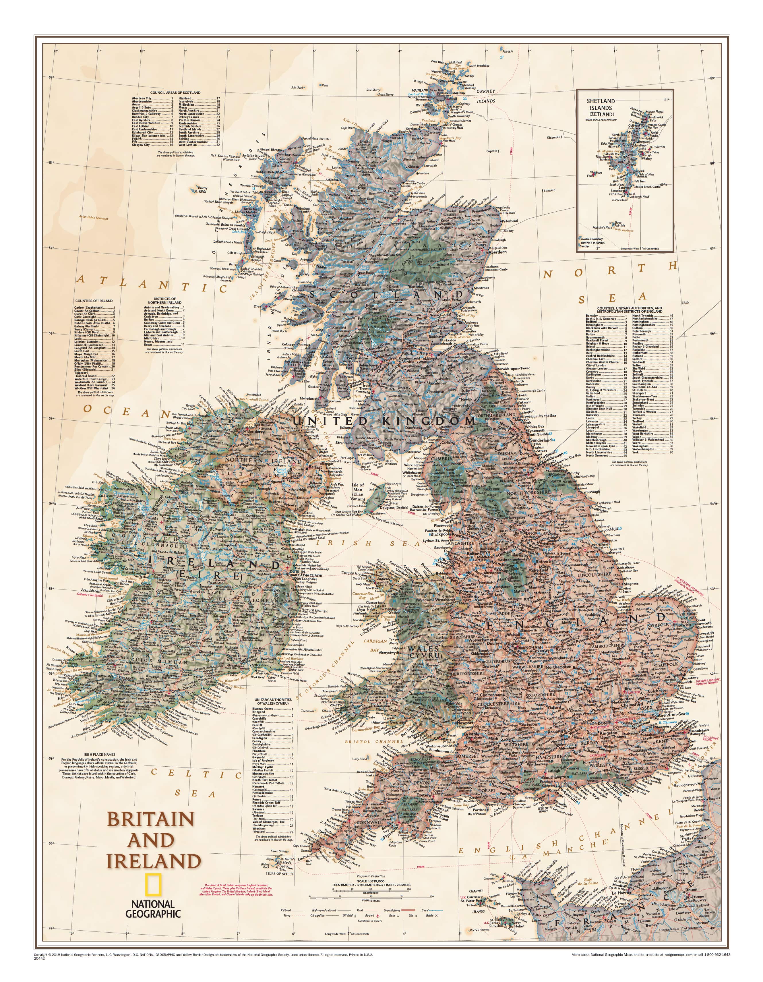
Britain & Ireland Executive Antique Style National Geographic 597 x 768mm Wall Map
$59.95
or make 4 interest-free payments of
$14.99 AUD
fortnightly with
![]() More info
More info
National Geographic's Executive political map of Britain and Ireland is both an attractive addition to any study or classroom and an informative tool for exploring these fascinating countries. The map features thousands of place names, major highways and roads, airports, ferry routes, bodies of water, and more. Handy indexes make it easy to identify the counties, districts, council areas, unitary authorities, and metropolitan districts of Ireland, Northern Ireland, Scotland, Wales, and England.
An inset provides details of the Shetland Islands. National parks are clearly indicated in green vignettes, and shaded relief reveals the interesting and varied topography of these island nations. English and Gaelic (Irish) share official status per the Republic of Ireland's constitution, so place names are rendered in both. In the Gaeltacht or predominantly Irish-speaking regions, only Irish place names have an official status and are used on signposts. These districts are found within the counties of Cork, Donegal, Galway, Kerry, Mayo, Meath, and Waterford.
The map can come either printed on heavyweight 160 gsm paper or laminated. The paper version is perfect for framing under glass, and the laminated version is exceptionally hard-wearing as we use a true encapsulation of two pieces of 80-micron gloss laminate.
Alternatively, we can supply this map on 395 gsm HP Professional Matte Canvas using pigment-based inks, making the map highly durable and fade-resistant. The exceptional clarity of printing makes this map a stunning addition to any room, and its high quality means that it will provide years of enjoyment.
The easiest way to hang your canvas map is by having wooden hang rollers attached top and bottom with a hanging cord on the top roller, so all you have to do is put a hook on the wall. The hang rails come lacquered in a natural timber colour.
Published: 2018
Scale: 1:1,678,000
Size: 597 mm (w) x 768 mm (h)
Note: Please allow ten working days to deliver hang-railed maps as they need to be attached by our framer.
Made in Australia
Customer Reviews
Based on 2 reviews
Write a review
Related Items


© 2024 Mapworld. Website designed by Genie Media
X