- Australia ▾
- Topographic
▾
- Australia AUSTopo 250k (2025)
- Australia 50k Geoscience maps
- Australia 100k Geoscience maps
- Australia 250k Geoscience maps
- Australia 1:1m Geoscience maps
- New Zealand 50k maps
- New Zealand 250k maps
- New South Wales 25k maps
- New South Wales 50k maps
- New South Wales 100k maps
- Queensland 10k maps
- Queensland 25k maps
- Queensland 50k maps
- Queensland 100k maps
- Compasses
- Software
- GPS Systems
- Orienteering
- International ▾
- Wall Maps
▾
- World
- Australia & New Zealand
- Countries, Continents & Regions
- Historical
- Vintage National Geographic
- Australian Capital Territory
- New South Wales
- Northern Territory
- Queensland
- South Australia
- Tasmania
- Victoria
- Western Australia
- Celestial
- Children's
- Mining & Resources
- Wine Maps
- Healthcare
- Postcode Maps
- Electoral Maps
- Nautical ▾
- Flags
▾
- Australian Flag Sets & Banners
- Flag Bunting
- Handwavers
- Australian National Flags
- Aboriginal Flags
- Torres Strait Islander Flags
- International Flags
- Flagpoles & Accessories
- Australian Capital Territory Flags
- New South Wales Flags
- Northern Territory Flags
- Queensland Flags
- South Australia Flags
- Tasmania Flags
- Victoria Flags
- Western Australia Flags
- Gifts ▾
- Globes ▾
Dear valued customer. Please note that our checkout is not supported by old browsers. Please use a recent browser to access all checkout capabilities


Africa National Geographic 610 x 780mm Wall Map
$59.95
or make 4 interest-free payments of
$14.99 AUD
fortnightly with
![]() More info
More info
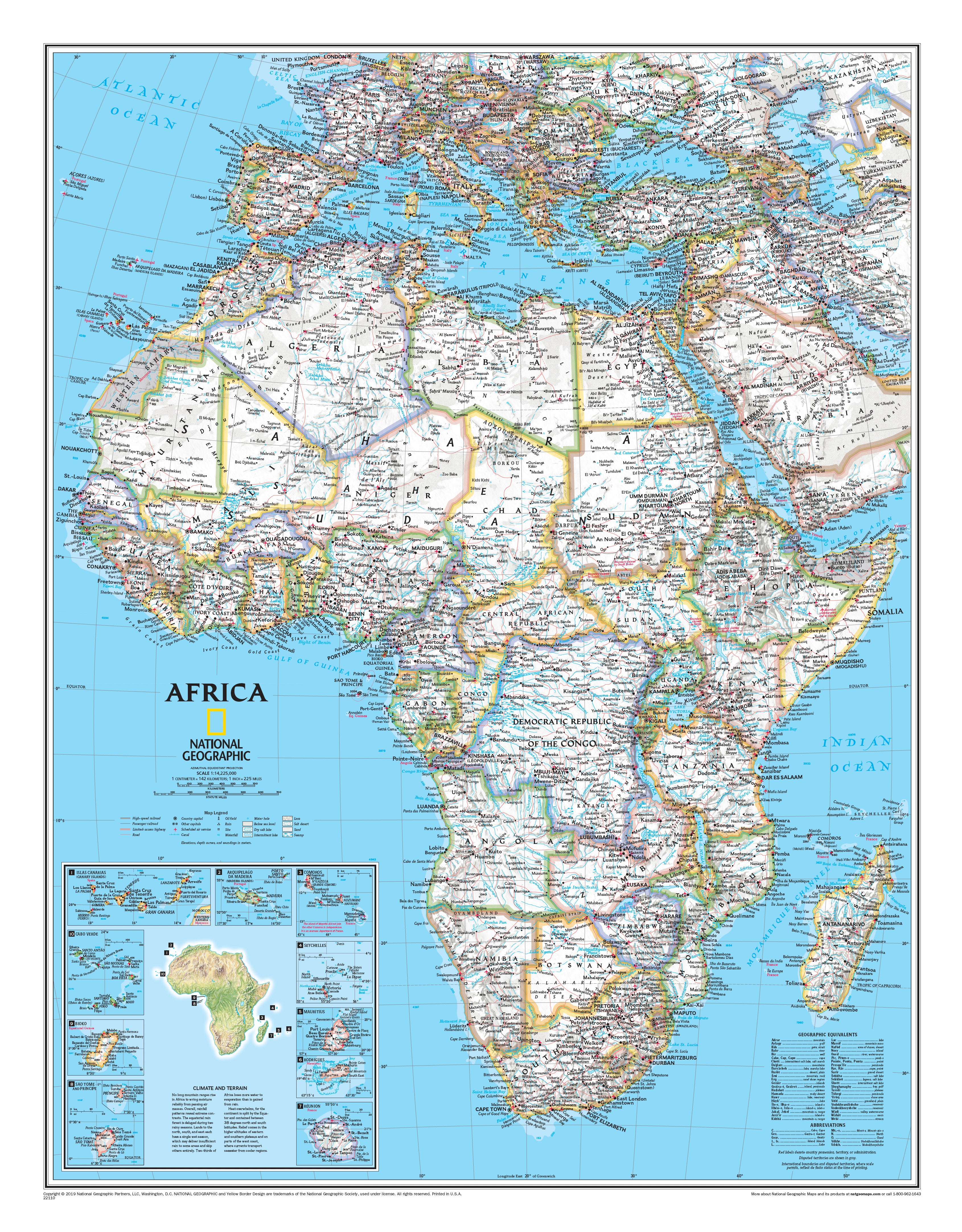
🌍 Africa Classic-Style Wall Map
National Geographic | 610 x 780 mm | Political & Physical | Classic Colour Palette
A bold and brilliant tribute to the heart of the world’s oldest continent.
Africa, rendered in vivid colour and precision detail. This Classic-Style Wall Map by National Geographic presents the grandeur of the African continent in a form that is both functional and visually captivating. Blending decades of cartographic excellence with National Geographic’s iconic style, this map is the ideal fusion of education, artistry, and inspiration.
Whether you're tracking African history, exploring its complex geography, or simply decorating with intention—this is the map that invites curiosity, conversation, and admiration.
🗺️ Cartographic Features & Detail
Every element of the map has been carefully designed to inform and inspire. This is a reference tool made beautiful:
-
🟢 Clearly defined international borders with vibrant colour coding for each country
-
🏔️ Shaded physical relief shows mountains, plateaus, and valleys in stunning 3D-style elevation
-
💧 Rivers, lakes, wetlands, dry salt lakes, and intermittent water bodies
-
🏜️ Depictions of lava fields, deserts, swamps, and areas below sea level using intuitive symbols and cartographic textures
-
🛫 Major highways, airports, and road networks
-
🧭 Inset topographic map of the continent highlights elevation and landform variations
-
🏝️ Inset maps of 10 surrounding island nations including Madagascar, Seychelles, Comoros, and Cape Verde
-
🌡️ Climate and terrain inset – showcasing Africa’s immense climatic zones and ecological diversity
This is Africa—alive with colour, complexity, and cartographic elegance.
🖼️ Choose Your Perfect Format
This map is available in three premium display formats to suit every space and purpose:
| Format | Material & Finish | Ideal For |
|---|---|---|
| Paper | Printed on premium 160gsm matte paper | Perfect for framing under glass or behind Perspex |
| Laminated | Encapsulated in 80-micron gloss laminate (front and back) | Durable, waterproof, and compatible with whiteboard markers |
| Canvas | Printed on 395gsm HP matte artist canvas with fade-resistant pigment inks | Gallery-quality finish with textured richness and visual depth |
🪵 Optional Timber Hang Rails available for laminated and canvas versions.
🪚 Optional Timber Hang Rails (Canvas & Laminated Only)
Add a polished, ready-to-hang finish to your map with handcrafted timber rails:
-
🪵 Natural wood, satin-lacquered to a smooth finish
-
🧵 Corded top rail for quick and easy wall mounting
-
🖐️ Hand-assembled by a professional framer
-
🕰️ Please allow up to 10 working days for delivery of rail-mounted maps
A premium presentation for a map worth displaying.
📐 Map Specifications
| Feature | Details |
|---|---|
| Map Title | Africa Classic-Style Wall Map |
| Publisher | National Geographic |
| Map Style | Political & Physical – Classic colour palette |
| Scale | Approx. 1:13,000,000 |
| Dimensions | 610 mm (W) x 780 mm (H) |
| Inset Maps | 10 African island nations + terrain & climate overview |
| Print Origin | Proudly printed in Australia |
| Optional Extras | Timber hang rails (Laminated & Canvas versions) |
💡 Why Choose This Map?
🧠 Educational Brilliance – A visual learning aid that brings African geography to life with topography, climate, and political context.
🧭 Inspiring Exploration – Perfect for travellers, educators, students, and lifelong learners.
🏡 Decorative Elegance – Adds a sophisticated touch to offices, classrooms, studies, and reading nooks.
🖨️ Unmatched Print Quality – Vivid colours, clear labels, and high-resolution detail printed on premium substrates.
🎁 A Gift to Impress – Ideal for birthdays, graduations, retirement gifts, or as a present for a well-travelled friend.
🇦🇺 Made in Australia – Printed and finished locally using the highest-quality materials and environmentally responsible practices.
Let the Africa Classic Wall Map serve as your window to a continent of rich cultures, vast landscapes, and boundless diversity. With National Geographic’s trusted cartography and timeless design, this is a map to admire, explore, and treasure.
📦 Shipping Information
-
📄 Paper & Laminated maps: Usually ships within 1–2 business days
-
🖼️ Canvas & Hang Rail versions: Please allow 7–10 business days for professional assembly and shipping
🛒 Add to Cart & Explore Africa in Style
Whether for home, school, or the office—this map brings the world to your wall in a way only National Geographic can.
Frequently Asked Questions
What are the dimensions of the Africa National Geographic 610 x 780mm Wall Map?
Mapworld wall maps range from standard 700×1000mm to large-format 1000×1430mm Supermaps. The exact dimensions for this map are shown in the product title. Where multiple sizes are available, select your preferred size when adding to cart.
Is this wall map available laminated?
Many Mapworld wall maps are available in paper, laminated, or framed finishes. Check the product options when adding to cart. Laminated maps are wipe-clean and more durable.
Is this the latest edition?
Mapworld stocks the most current editions available from all publishers. Edition year is shown in the product title where applicable. Mapworld updates its catalogue as new editions are released.
Can I write on or pin this wall map?
Laminated wall maps can be written on with whiteboard markers and wiped clean. Paper maps can be pinned on a corkboard. Choose a laminated option for a writeable surface.
Does Mapworld ship the Africa National Geographic 610 x 780mm Wall Map across Australia?
Yes, Mapworld ships Australia-wide. Standard shipping is a flat $7 rate, with free standard shipping on orders over $75. Express options are available at checkout. Most orders placed before 2pm AEST on weekdays are dispatched same day.
Related Items


© 2026 Mapworld. Website designed by Genie Media
X